Mischief Managed
Notes on the queer use of maps, maps that are queer, and other technologies of way-finding-and-making.
“The map never lies,” says Professor Remus Lupin to Harry Potter, after Harry informs him that the Marauder’s Map pointed to the presence of a known-to-be-dead wizard in the Hogwarts castle.[1] The map in question, an invention of four adolescent wizard friends, allows its users to see anyone in the vicinity of the castle’s grounds in real time, as long as they promise to be “up to no good.” As a fan of the Harry Potter universe, its books, films, and fanfiction, I find the idea of the Marauder’s Map fascinating. There is something satisfying and subversive about this idea of a cartographic technology that can only be used as long as its users – in this case, a band of unruly students – commit to doing no productive good. It seems to me, however, that there is something flawed about the idea that a map made by teenagers could never make mistakes or lie.
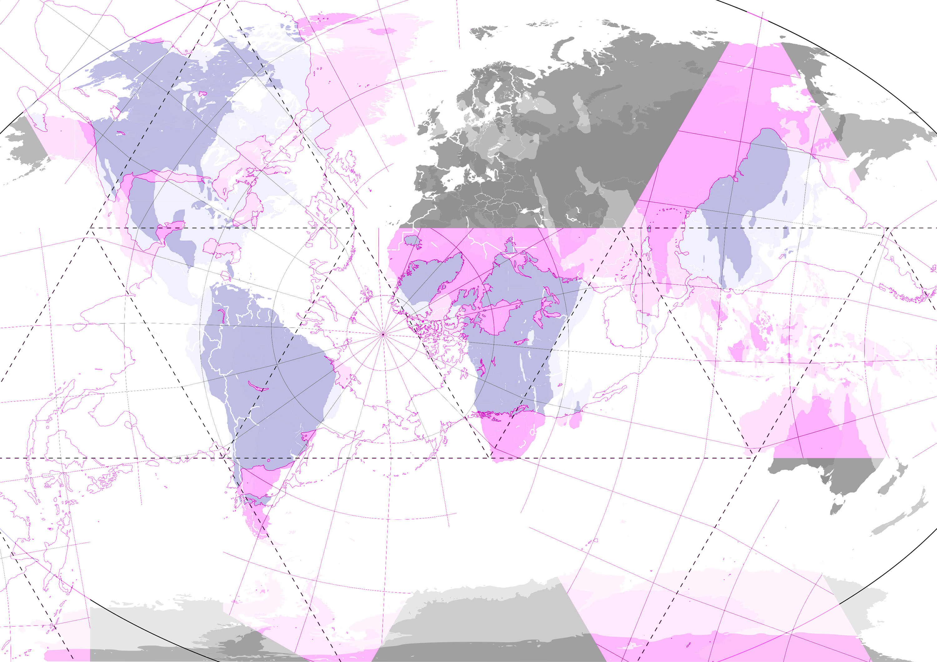
Collage of the Mercator projection, the Winkel tripel projection, the Gall-Peters projection, and the Dymaxion projection.
As Ruben Pater states in The Politics of Design (2016), the “notion that maps provide an objective or scientific depiction of the world is a common myth.”[2] In his critical examination of modern cartography, Pater ties its colonial origins to the difficult task of translating something spherical – like planet Earth – into a flat surface. A possible result is the “Mercator map,” which has been the standard map projection since it was drawn by Gerardus Mercator in 1569. The cartographer used “compass directions as straight lines” and depicted the world from a sixteenth-century Western European point of view. His drawing depicts the countries in the Northern Hemisphere as bigger than the ones in the Southern Hemisphere, thus demonstrating graphically the political and economic sovereignty of the West. Although many have pointed out that the Mercator map misrepresents the world, it is still used in geography classes, schoolbooks, and our phones – with apps like Google Maps and Apple Maps.[3]
Like the technology of cartography itself, the use of maps has evolved far beyond its original nautical purposes. This development, however, does not guarantee that a map, as a technology for finding one’s position(s) and way(s) in the world, is foolproof. This is a realization that came to me from the palm of my hand and motivated me to write this essay. During my last holiday, some friends and I wanted to travel from a small town in Italy’s southern coast to a slightly bigger town, where we would take a train to another town. Google Maps showed us several routes. We chose one, turned on our GPSs and, as good users do, walked to the departure point and waited for the bus to arrive. But it never did. We wandered around and found what looked like a memory of a bus stop: a precarious, rusting steel structure with broken glass, covered with band stickers and posters from the recent past. Puzzled, we rummaged through the website of the Italian Railway and managed to find out where the bus actually departs from. One hour later, we took it. Actually we should have noticed from the start that something was wrong. The route of the bus, as visualized by the app, was the main giveaway. The red line traveled over the ocean and crossed multiple roads before somehow arriving at its destination. It was nonsense, and yet Google Maps, with its supposedly seamless, all-knowing interface, clouded our judgment. This made me think about how the app’s database works much like my memory, with its average human unreliability at remembering information and its ineffectiveness at retaining it. Maps, especially ones like Google Maps, are dressed in the digital gloss of seamlessness and are good at making us believe that what they tell us is true, while many times it is not. What I would like to think through in this text is how such moments of informational glitch in Google Maps – a technology that is allegedly always up to date – may help us critically investigate our relationships to these way-making technologies, while at the same time inspiring the creation of alternative maps.
I use Google Maps almost every day, primarily to estimate how much time it will take me to go from place A to place B. Having lived in Vienna for over four years now, I would say that I know my way around. Nevertheless, I continue using Google Maps as a means of self-assurance. While most of the time I do not follow Google Maps’ directions, it does gives me extra confidence that if I happen to lose my way, I know it will guide me back because generally it is right. It is easier to make mistakes if you know the correct answer isn’t far away. Often, when I happen to veer off the recommended path, I come across something new – a park, a shop, a place to eat. In such situations, I navigate public space by simultaneously forgetting and keeping Google Maps in mind. This allows me to pin things that are of interest and/or important: where I work, where my friends live, where most of my social interactions take place. Using Google Maps is not just about finding my way around but also about keeping track of my way(s) in the world. While I could tackle this subject from the point of view of privacy and the ways in which Google Maps learns from my habits, I would rather examine the moments when it fails to meet my expectations.[4]
While technology renders itself invisible through its smoothness, glitches and failures serve as reminders of its presence. It is in the moments that Google Maps does not work that I notice it. As Sara Ahmed suggests, “[w]hen something stops working or cannot be used, it intrudes into consciousness.”[5] There is a lot to be learned about tools by examining how they are used. In her book What’s the Use? On the Uses of Use (2019), Ahmed traces the process by which the word “use” acquired its symbolic status and how it is used in language. She wants to understand how “use” gives form to things, bodies, and spaces, and how “use” can change depending on where and when something or someone is “put to use.” Ahmed’s vast project tackles the term “use” through various analytical lenses from literature, philosophy, biology, gender studies, and institutional critique. These multiple threads are brought together by the idea of “queer use,” which has informed the way I think about the projects discussed below.
The combination of the words “queer” and “use” might suggest that there is also something we can call “straight use” that represents the intended functionality of the object. Designers, myself included, usually design things with their “straight use” in mind. When I design a poster for an event, I want to convey information in such a way that as many people as possible are interested enough to show up. What I do not think about when I design a poster is how it will be used to decorate the venue of the event, how it will hang in people’s homes like a painting, or how it will eventually be used as Christmas wrapping paper.[6] While some things are shaped by how they are used, use itself is shaped by what can be done with those things, both materially and technologically. To use something in a queer way means using it “for purposes other than … intended.”[7] “Queer use” highlights the individual qualities of things, “rendering them all the more lively.”[8] To make use of something in a queer way means unleashing the potential of a thing by paying attention to what else it can do. While I myself, as a queer person, would like to read “queer use” in a strictly positive way, it must also be pointed out that uses can also be discriminatory, such as using the collaborative features of Google’s Local Guides platform, which allows users to change the names of buildings as a way to keep local information up to date, to incite racism.[9]
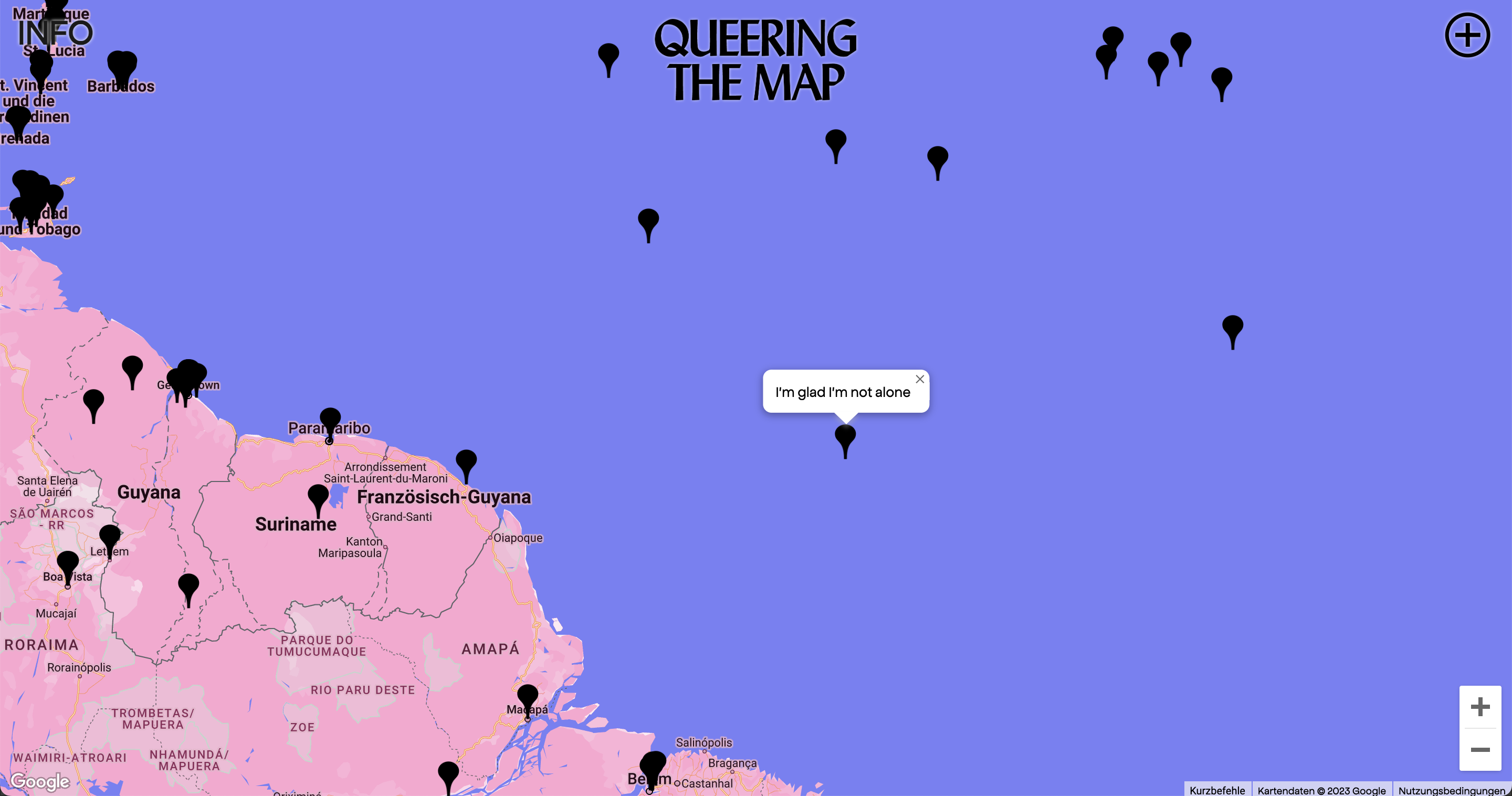
Photoshopped screenshot of Queering the Map.
On account of the Google Maps’ failure during my holiday and Ahmed’s description of “queer use,” I started looking differently at way-finding and way-making technologies. The ghostly bus stop may have a remnant of some path that was once useful to someone else. The fact that an “out of use” bus stop appears on a map is a glitch. This glitch is a witness to the map’s memory. This bus stop is a memory, although maps are not supposed to have memories. It is a leftover, the removal of which has been delayed. In an attempt to gather such leftovers, spaces that were once “put to use,” even if only for a fleeting moment, designer Luca LaRochelle created Queering the Map, a platform that engages with the question of what "futures might emerge from this kind of embodied knowledge.”[10] This “community-generated, counter-mapping project" allows its users to record their experiences as text and place them in the physical space of a map, therefore exploring the tension between physical reality and affective memory.[11]
As a frequent visitor to the website since its first iteration in 2017, I have been surprised by its current size: the pink world map, sourced from Google’s API, is flooded with black pins representing individual contributions to the platform. While reflecting on the platform’s development, LaRochelle has pointed to the difference between understanding Queering the Map as a map of queer stories (which it is) and as a map that is “queer."[12] While the former points to the platform’s content, the latter grasps its form. To design a map that is queer or a map that is meant for “queer use” can point to two different desires. One aligns with Ahmed’s concept of “queer use,” meaning a map that is used in a way other than how it was intended, while the other points to its intended usership. In the case of Queering the Map, this distinction is irrelevant since the platform performs both.[13] It is a digital map that creates a space for a worldwide community of queers that is outside of “algorithmic control” and the “endless north/south (straight) scroll,”[14] thereby using of a map not to find one’s way, but to lose one’s way.[15]
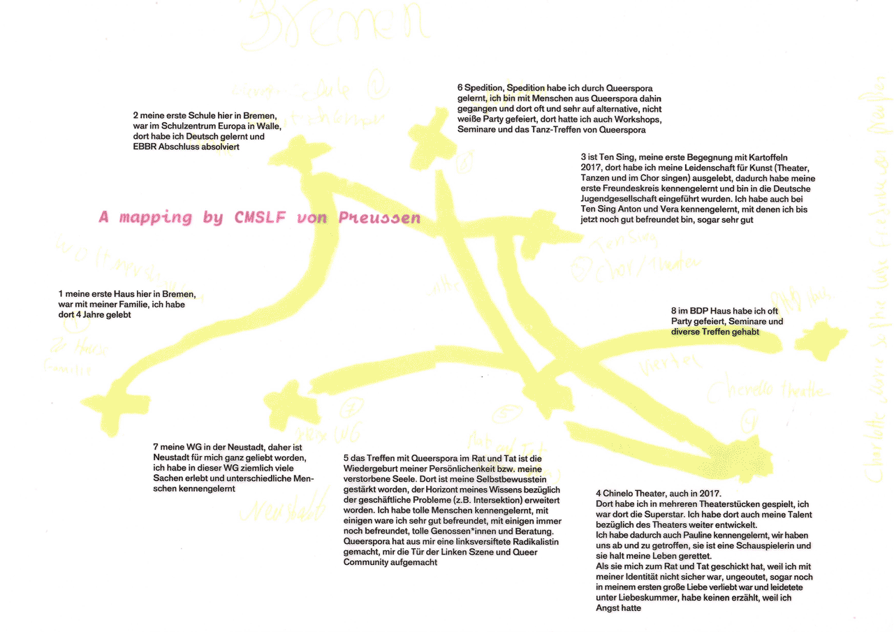
GIF made out of scans of the Queeraspora publication
Queering the Map conceived of a map that is queer because it helps its users lose rather than find their way. The publication Queeraspora Collective Mapping is as much about collecting single points to be found or lost as it is about the lines that can be drawn between them. The publication, which stems from a collaboration between Queeraspora,[16] Queer narratives, mapped,[17] and city/data/explosion,[18] is “the self-documentation of the daily lives of its contributors and their personal geographies as queer (post-)migrants, refugees, BIPoCs in the city of Bremen.”[19] Slightly bigger than a horizontal DIN A4, the book is held together by only two Chicago screws, suggesting that this project is a work in progress.
The publication contains the “self-documentation” and “personal geographies” of its contributors, not in the form of traditional maps, but as hand-drawn lines that are printed on transparent paper. These colorful lines form crisscrossing paths; sometimes they form shapes akin to a city map or to a scene in a comic book. Some lines are straight and sharp, while others are made up of smaller lines or dots. Similar to LaRochelle’s Queering the Map, these personal maps do not designate specific spaces, streets, or buildings, but instead document individual queer and diasporic experiences and relationships to the city. While some of these maps are concerned with city spaces, for instance bus stops, squats, and public buildings where queer demonstrations or Queeraspora meetings have taken place, others are memory and narrative driven, drawing lines through time, not space. They recall moments of joy and/or struggle upon arriving to a new city, excitement about new opportunities, frustration about being misunderstood, and curiosity upon discovering a queer BIPoC scene where they feel welcomed. What is generative about the publication is that its design allows contributors and readers to place individual maps onto the collective stack of queer diasporic memories in order to discover overlapping moments. In the very way in which the publication is bound, the maps not only represent individual experiences, but also reveal affinities and differences within this community. The publication features inlays with pixelated images of meetings and happenings by and for Bremen’s queer diaspora community. It is only on the last page of the publication that we find a satellite image of the city of Bremen, which situates these “personal geographies” in space.
Projects like Queering the Map and Queeraspora Collective Mapping are able to create room for experiences and memories that are at once polyphonic and singular, harmonious and dissonant. These projects make “all the more lively”[20] the potential of mapping tools to serve as archives of human memory and experience.
Going back to Google Maps, the Mercator projection, and Ruben Pater’s discussion in The Politics of Design, it would be interesting to ask a different design question: What if the problem of and about maps is not necessarily about form but rather about practice? If the function of a map is to help find one’s way, from whose perspective do “we”[21] look at public space? In the spirit of Queeraspora Collective Mapping, and in light of current technological possibilities, especially platforms like Google Maps, we may ask: How many maps fit into one
As I come to the end of this text, I notice how I have prioritized the information that maps give me over what takes place in public space. I often forget that streets, parks, and buildings are memories in and of themselves, holding traces within the pavement, walls, and ground. In Vienna, the city I reside in, the city's administrators are quite preoccupied with preserving monuments, buildings, and other urban infrastructure. There is also a community of researchers, artists, and architects, who reflect critically on the urban landscape and its ties to Austria’s fascist and colonial past(s).[22] One such individual is Andreas Brunner, a co-founder of QWIEN – Zentrum für queere Geschichte Wien, who offers regular queer walking tours (Queere Stadtspaziergänge).[23] QWIEN offers tours about the her*histories of queer people in Vienna as a way to communicate to residents and tourists alike the heavily researched and theory-based work that they do as an archive, a library, and a research institution. By making these her*histories visible and accessible, Brunner anchors them in the city’s history and, like Queering the Map and Queeraspora Collective Mappings, makes well-traveled paths and queered spaces from the past accessible again to younger generations who might still feel lost in Vienna’s straight ways. One focal point of these tours is the persecution of queer people during the Austrofascist period.[24] Oftentimes, reflecting on these stories of persecution is a difficult but necessary task. There were few records of queer people at the turn of the 19th and 20th century, and many of them come from criminal files and police reports.[25] By reading these documents in ways other than intended, researchers are able to piece together traces of queer existence. By using the format of the guided tour to disseminate this information, Brunner makes “queer use” of it, not only by providing information about the places and people, but also by reconstructing and reactivating relationships that History[26] was unwilling or unable to sustain.
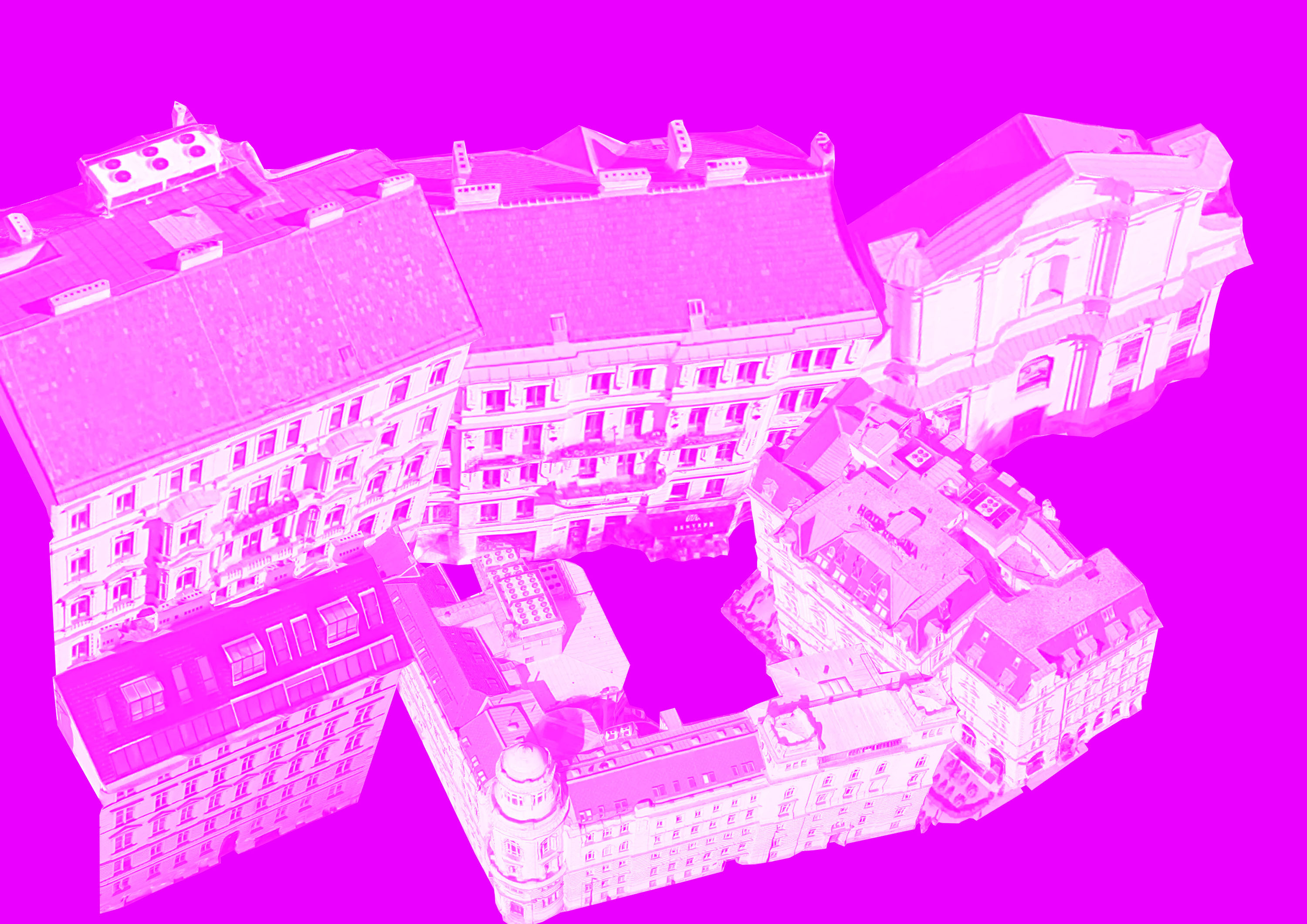
Photoshopped screenshot of Google Street View of the Hotel Regina in Vienna.
In this text, I wanted to take the first step toward exploring how designers, technologists, researchers, and activists make use of tools and technologies for “way-finding and making” that can be considered queer. Here “queer” means, as Sara Ahmed suggests, making use of something in ways other than it was intended and using something with a queer user or audience in mind. In compiling this collection of projects and practices, I wanted to identify a number of projects that use mapping technologies in different media and that are engaged in grassroots practices of activating public space with and for queer people. The tools with which we, queer designers and technologists, map our world, our relationships, and our lives in public and private spaces will only be adequate to those for whom and by whom they were created. This essay is an attempt to encourage reflection on practices that address public space in both its real and virtual manifestations through the lenses of memory, affect, and embodied knowledge.
Until we see each other again, “Mischief managed!”[27]
J.K. Rowling, Harry Potter and the Prisoner of Azkaban (London: Pottermore Publishing, 2015), 334, https://books.apple.com/at/book/harry-potter-and-the-prisoner-of-azkaban-enhanced-edition/id1037196784. ↩︎
Ruben Pater, The Politics of Design (Amsterdam: BIS Publishers, 2016), 152. ↩︎
For a comprehensive critique of the use of the Mercator Map in education, see: Delon Alain Omrow, “A map of the World: Cognitive injustice and the Other,” Journal of Philosophy and Culture Vol.8 (2), pp. 22-32, July-December 2020, https://doi.org/10.5897/JPC2020.0057. Also, in 2018, Google Maps enabled in its Desktop Version the “3D Globe Mode” as its standard view, allowing the map to represent the world in a more accurate manner. see: Andrew Liptak, “Google Earth now depicts the Earth as a globe,” The Verge, August 5, 2018. https://www.theverge.com/2018/8/5/17653122/google-maps-update-mercator-projection-earth-isnt-flat. ↩︎
The issue of privacy within Google Maps' reviews feature has been extensively analysed in: Kevin De Boeck, Jenny Verdonck, Michiel Willocx, John Lapin, and Vincent Naessens, “Reviewing review platforms: a privacy perspective,” ARES '22: Proceedings of the 17th International Conference on Availability, Reliability and Security, Association for Computing Machinery, New York, NY, USA, Article 8, 1--10, https://doi.org/10.1145/3538969.3538974. ↩︎
Sara Ahmed, What's the Use? On the Uses of Use (Durham: Duke University Press, 2019), p. 21. ↩︎
Interestingly, in What's the Use?, Ahmed makes reference to the way the word “queer” used to be employed meaning “reused.” In her Conclusion, Ahmed quotes a newspaper article from 1899 titled “Queer Use for Cloisters.” See, Ahmed, p. 199. ↩︎
Ahmed, p. 26. ↩︎
ibid. ↩︎
Here I reference the digital vandalism case that resulted in searches for the “N-word\” to indicate “The White House.” For more information see: Brian Fung, “The Internet has unearthed more racist Google Maps resulst,” The Washington Post, May 21, 2015. https://www.washingtonpost.com/news/the-switch/wp/2015/05/21/the-internet-has-unearthed-more-racist-google-maps-results/. ↩︎
Luca LaRochelle, “Queering the Map: on designing digital queer space,” in: Queer Sites in Globals Contexts. Technologies, Spaces, and Otherness ed. Regner Ramos and Sharif Mowlabocus (London and New York: Routledge), p. 133. ↩︎
ibid. ↩︎
LaRochelle, p. 142. ↩︎
In the context of this contribution, it is a distinction that is irrelevant since the examples I share here both encompass the use of technologies in queer ways and for a/the queer community. Nevertheless, I find it important to make this distinction, since the term “queer” is increasingly used outside of a strictly identity politics context to signify a deconstruction of binaries. ↩︎
LaRochelle, p.42. ↩︎
As LaRochelle states in their article: “To be lost is a feature not a bug.” ↩︎
Queeraspora is an association based in Bremen working toward the organisation of safe-spaces for queer BIPoCs in Bremen, community empowerment and network, as well as anti-discriminatory and anti-racist work and policy making. For more information about the association and their activists, see: https://migrantenorganisationen-bremen.de/organisationen/queeraspora-bremen/, and https://www.instagram.com/queeraspora/?hl=en. ↩︎
Queer narratives, mapped? is a working group that was born out of two workshops, one in 2019 and another in 2020, both of which dealt with the record of queer spaces, traces, and memories in the form of a digital map, as well as the reflections generated through the project's visual outcomes and documentation. ↩︎
city/data/explosion examines the overlapping of digital communication and physical spaces, the evaluation and negotiation of digital and social media in the public sphere between control society and self-empowerment, the perception of public spaces and social public sphere through the filters of these very media. For more information, see: https://citydataexplosion.tumblr.com/about. ↩︎
Queeraspora Collective Mappings, ed. Queeraspora and “Queer narratives, mapped” working group (Bremen: kunst- und Kulturverein spedition e.V.). ↩︎
Ahmed, p. 26. ↩︎
When I say “we,” I mean designers and technologists that identify as “queer” and with practices that are “queer” and make “queer use” of existing technologies. ↩︎
I would like to take a moment to name a few of these individuals and collectives: the artist group Schandwache (Anna Witt, Simon Nagy, Gin Müller, Mischa Guttmann, Eduard Freudmann), the collective Decolonizing in Vienna!, Lisa Bolyos und Tomash Schoiswohl's project “Immo Grief,\” as well as architect and activist Gabu Heindl. ↩︎
For more information about the different tours offered by QWIEN, see: https://www.qwien.at/guide/. ↩︎
For a comprehensive overview of QWIEN's multiple research foci, see: https://www.qwien.at/forschung-projekte/. ↩︎
The records of a community and its individuals is contingent on the technology of the time as well as to an individual's social standing and context. There are, of course, a number of queer personalities, specially members of the Austria-Hungary monarchy, actors, and writers, all of which have been immortalised in written biographies, films, etc. The point that I try to make here is more about the social history of a queer community rather than of a selected few. ↩︎
I use here the word “history” with a capital “H” to refer to hegemonic history, told in history books from a perspective that is often white, male, cis-straight, middle-class, and stemming from Global North countries. ↩︎
By placing one's wand on the Marauder's Map and saying the words “Mischief managed,” its user makes sure that others trying to see the contents of the map will only find an empty parchment. ↩︎